N 17.0907020
E 48.0804840
Pheasantry in Jarovce
- Home
- History
- Description of the park
- Fauna and flora
of the park  Múdre stromy
- Current use
- Contact
- Plan your way
- Opening hours
-
The park is not normally accessible
to the public
Pheasantry in Jarovce
In the Baroque period, specific interventions in the rural landscape began to appear, inspired by the principles applied in urban development. Urban patterns, which are mainly understood as the geometrization of floor plans, straight roads facilitating movement, and the sharp and clear division of spaces, were also reflected in landscape compositions. In the 18th century, several natural spaces were created in the surroundings of Bratislava, in which the aforementioned Baroque principles were applied. One of them is the Bažantnica in Jarovce.
Type:
historical park / garden
Facilities:
National cultural monument
Style:
barokový
Region:
Bratislava
City/village:
Bratislava, mestská časť Jarovce
Address/Location:
Bratislava, Jarovce City District
Altitude:
135 m n. m. m a.s.l.
Nearby attractions:
EuroVelo 13 – Iron Curtain Bike Trail


Múdre stromy
History
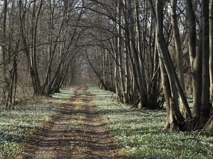
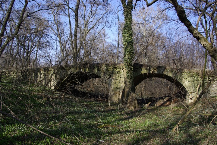
Pheasantry was probably built in the first third of the 18th century, but it is possible that this space existed and was used even earlier. Although it is located in Slovakia, its fate is closely linked to the nearby town of Kittsee in Austria. There is the so-called Neues Schloss (New Castle), to which it belonged. The castle was built at the beginning of the 17th century and in 1730-1740 Paul Anton Esterházy rebuilt it into a Baroque manor house. In the same period, the Pheasantry was probably built as a hunting lodge. The Pheasantry is first recorded on the map of Hungary from 1754 to 1755, and almost the same condition is recorded on the map from the 1st military mapping from 1769 to 1785. On both maps it is connected to the town by a road with a two-sided avenue. The castle building is approximately 2,5 kilometres away from the Pheasantry. The irregular hexagonal shape of the Pheasantry was created by modifying the original forest, which was preserved in the agricultural landscape. Almost its entire area was surrounded by the meander of the Danube. A stone bridge with two arches crossed the river arm. The whole area was fenced with a stone wall. The Pheasantry was divided into eight segments by a star-shaped road network with eight arms and a central circular area. The roads that formed the star-shaped grid were connected to each other by other roads perpendicular to each other. One of the roads continued in a north-easterly direction towards a small wood in which the 'Lusthaus', i.e. the summer house, was situated. Alleys, probably of lime trees, lined the main roads of the Pheasantry. Only remnants of these have survived to this day. According to the maps, there were several buildings in the Pheasantry. One of them was the Jägerhaus, where the property keeper lived, the other was a stone bridge and outbuildings on the southern edge.
The development of the Pheasantry in the 19th century can be well traced with the help of the surviving maps. On the map of the 2nd military mapping (1810-1869), the Pheasantry is marked as 'Thirgarten', which reflects the fact that game other than pheasants, such as roe deer or hares, were kept here. The summerhouse no longer exists, but the wood and the access road with the avenue do. On the map of the 3rd military mapping (1875-1884), the name 'Fasengarten' (Fasangarten), i.e. pheasant farm, appears again, and the former 'Jägerhaus' is marked as 'Wildhüter', i.e. grove. During the 19th century, the outbuildings of a bailey appear in the eastern part of the Pheasantry (on the outer side of the Danube arm). Houses were built in two opposite rows for its employees in nearby Kittsee on the former pasture land (today's Krachgasse street).
After 1945, the Pheasantry was gradually devastated. In 1947 the wall was dismantled and the other buildings gradually fell into disrepair. On maps from the period 1952-1957, the bailey is marked as a ruin.
Description of the park
The Pheasantry has an irregular floor plan with a hexagonal shape. Eight-armed clearings with a central circular area have been cut into the original forest cover.
Nowadays, the Pheasantry is a little-known natural area of Bratislava, in which the original star-shaped layout has been partially preserved. The tree rows that lined the individual roads have already come of age, only the torsos of the trunks of the massive lime trees have been preserved.
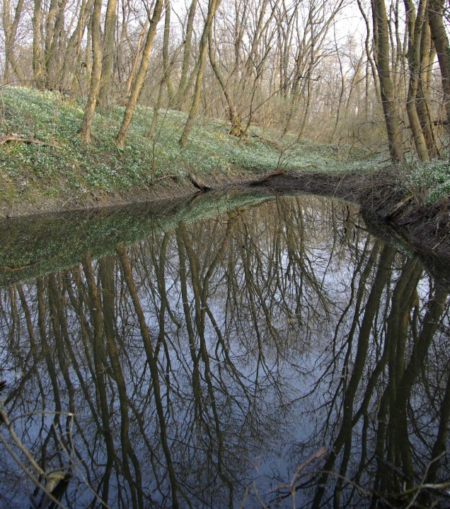
The double-arched stone bridge over the original Danube arm is in a state of disrepair, but is still an impressive architectural feature. The arm of the Danube has been preserved only in the form of terrain depressions, which are replenished by groundwater and thus create larger or smaller water bodies.
Fauna and flora of the park
The most valuable are the tree plantations that lined the individual roads, although only the torsos of the trunks or stumps of the mighty lime trees have been preserved.
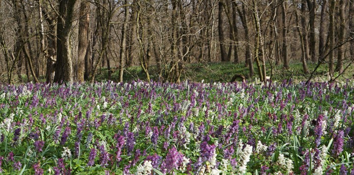
The Pheasantry is most attractive in spring when it is covered with thousands of snowdrops or hollow roots (Corydalis cava) and bear's garlic.
List of Wise Trees in this park
Múdre stromy
List of Wise Trees in this park
Current use
The Pheasantry of Jarovce is an important element of ecological stability.
Contact
Lesy SR š. p., SNP č. 8, 97566 Banská Bystrica 1
Plan your way
by foot from Petržalka, by car on route 1020.Opening hours
Bažantnica is currently inaccessible to the public: 4th level of protection is applied in the area and according to the Act No. 543/2002 Coll. regarding the conservation of nature and landscape visitors are forbidden to move outside the marked hiking or nature trails.